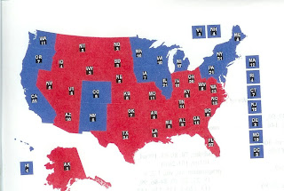
I did the interactive electoral map at RealClear Politics and chose the states (blue) I thought Obama could put in his column and thus win the election.
The geographical elements were so strong that it reminded me of a previous blog in which I set forth a geographical theory of politics. It is so prescient and so brilliant (ha ha) that I dare to repeat it here.
Thursday, November 18, 2004
A Geographical Theory of Winning in 2008
Look at the electoral maps of 2000 and 2004. The geographical pattern is striking, allowing for minor exceptions. The blue Democratic states are the Northeast, the upper Midwest, and the states bordering the Pacific. The red Republican states are the Southeast, Southwest, lower Midwest, mountain and plains states. A pre-Civil War map showing free (blue) and slave (red) states and territories almost exactly matches the electoral map of 2004.
While electoral maps of many other years would not be this striking, a geographical factor is present, except in blowout years like 1936, 1972, and 1984. Look at it another way. Democrats won the large cities, while Republicans won the small towns and rural areas, with the suburbs split. Divisions are also noticeable with regard to income, education,, religion, race and ethnicity, age, marital status, and gender, but geography is relevant to many of these as well. Zip code is an important clue all by itself.
Since this is a blog and not a book, what can we learn from this? Geography is a useful clue to many other things -- history, economics, religion, and culture. The geography of the South, e. g., was conducive to cotton growing and therefore slavery, which has deeply affected its entire history. Geographical factors account in part for immigration patterns and the Protestant domination of the South.
Geography is a component of, if not clue to, how things worked out in other areas with regard to economics, culture, and religion. So what does this mean for 2008? Assuming that the situation will remain much like it is now in terms of red and blues states as is probable, ask how the blue states can be preserved for the Democrats while reaching out to enough other states that can be likely won to win the election. Some decisions are easy. Massachusetts is probably a safe bet if the Democrats don't do something crazy, but forget Utah for a while. Either Florida or Ohio is probably a must, remembering that a shift of only 70,000 votes in Ohio in 2004 would have given the victory to Kerry.
Looking toward 2008, Democrats live in tension between holding true to their values and getting elected. How to win without losing your soul -- that is the question. With Gov. Mark Warner of Virginia, we risk losing our soul. With Sen. Hillary Clinton, we risk losing the election. My sentimental favorites at the moment are John Edwards and Barack Obama, but time may question the wisdom of one or both. But to begin with candidates, issues, and values is to get the cart before the horse. We need to start with geographical, historical-cultural factors and make a structural analysis of where enough more votes can come from next time to enlarge the number of blue states. Then we can match messenger and message to that purpose.
No comments:
Post a Comment